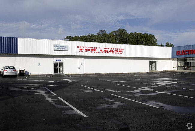
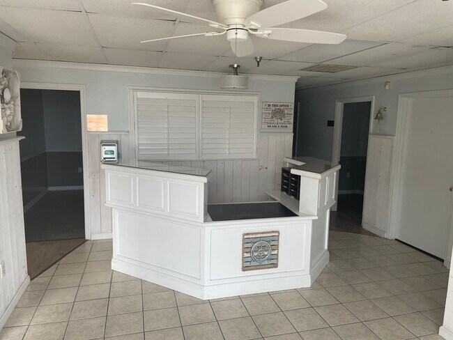
Property Record
2013 Lejeune Blvd, Jacksonville, NC 28546

NEARBY LISTINGS FOR SALE OR LEASE
Property Detail
2013 Lejeune Blvd
Jacksonville, NC
Jonathan Popkin
031861
L1 JONATHAN POPKIN
Officebuilding
Onslow
X
North Carolina
3720438600J
1
2025
2.73 AC
2025
North Carolina Southeast Area
002202
Other Market Areas
18,000 SF
DEMOGRAPHICS near 2013 Lejeune Blvd
1 Mile
3 Mile
5 Mile
2024 Total Population
8,978
34,010
75,137
2029 Population
9,576
36,051
79,342
Pop Growth 2024-2029
+ 6.66%
+ 6.00%
+ 5.60%
Average Age
27
31
31
2024 Total Households
3,596
12,509
25,723
HH Growth 2024-2029
+ 6.81%
+ 6.40%
+ 6.08%
Median Household Inc
$39,538
$47,469
$50,979
Avg Household Size
2.40
2.50
2.50
2024 Avg HH Vehicles
2.00
2.00
2.00
Median Home Value
$137,140
$157,473
$164,070
Median Year Built
1996
1988
1990
Nearby Places
Map Layers
Map Styles
 Street
 Aerial
- Restaurants
- Banks
- Shops
- Fitness
- Groceries
PUBLIC TRANSPORTATION
AIRPORT
Albert J Ellis
DRIVE
WALK
Distance
Albert J Ellis
32 min
17.6 mi
Coastal Carolina Regional
DRIVE
WALK
Distance
Coastal Carolina Regional
60 min
43.3 mi
Freight Ports
Port of Morehead City
DRIVE
WALK
Distance
Port of Morehead City
63 min
40.7 mi
SALE & LEASE HISTORY
LISTING DATE
SALE/LEASE

Oct 26, 2022
For Lease
Nearby Properties
Address
Land Use
TOTAL SIZE
Lot Size
Zoning
Address
Land Use
TOTAL SIZE
Lot Size
Zoning
244,010 SF
52.70 AC
CC
Address
Land Use
TOTAL SIZE
Lot Size
Zoning
11,192 SF
64.76 AC
OI
Address
Land Use
TOTAL SIZE
Lot Size
Zoning
164,207 SF
43.55 AC
OI
Address
Land Use
TOTAL SIZE
Lot Size
Zoning
204,711 SF
9.70 AC
CC
Address
Land Use
TOTAL SIZE
Lot Size
Zoning
40,838 SF
48.30 AC
O-I
Address
Land Use
TOTAL SIZE
Lot Size
Zoning
3,369 SF
79.40 AC
RMF-LD
Address
Land Use
TOTAL SIZE
Lot Size
Zoning
78,855 SF
40.49 AC
R-5
Address
Land Use
TOTAL SIZE
Lot Size
Zoning
7,740 SF
16.50 AC
RMF-LD
Address
Land Use
TOTAL SIZE
Lot Size
Zoning
12,745 SF
30 AC
R-5
Address
Land Use
TOTAL SIZE
Lot Size
Zoning
10,368 SF
23.17 AC
CC
Address
Land Use
TOTAL SIZE
Lot Size
Zoning
828 SF
8.56 AC
RMF-HD
Address
Land Use
TOTAL SIZE
Lot Size
Zoning
7,008 SF
9.72 AC
RMF-HD
Address
Land Use
TOTAL SIZE
Lot Size
Zoning
18,312 SF
16.25 AC
IND
Address
Land Use
TOTAL SIZE
Lot Size
Zoning
1,584 SF
61.32 AC
PDR
Address
Land Use
TOTAL SIZE
Lot Size
Zoning
102,423 SF
10.04 AC
CC
Address
Land Use
TOTAL SIZE
Lot Size
Zoning
46,502 SF
11.03 AC
CC
Address
Land Use
TOTAL SIZE
Lot Size
Zoning
62,733 SF
12.80 AC
RMF-HD
Address
Land Use
TOTAL SIZE
Lot Size
Zoning
35,312 SF
3.13 AC
OI
Address
Land Use
TOTAL SIZE
Lot Size
Zoning
17,235 SF
7.05 AC
CC
Address
Land Use
TOTAL SIZE
Lot Size
Zoning
75,961 SF
5.96 AC
IND
Address
Land Use
TOTAL SIZE
Lot Size
Zoning
20,000 SF
18.97 AC
IND
Address
Land Use
TOTAL SIZE
Lot Size
Zoning
46,116 SF
1.20 AC
DTB
Address
Land Use
TOTAL SIZE
Lot Size
Zoning
7,432 SF
7.95 AC
RMF-HD
Address
Land Use
TOTAL SIZE
Lot Size
Zoning
958 SF
8.73 AC
RMF-HD
Address
Land Use
TOTAL SIZE
Lot Size
Zoning
12,348 SF
3.57 AC
OI
Address
Land Use
TOTAL SIZE
Lot Size
Zoning
102,544 SF
11.60 AC
IND
Address
Land Use
TOTAL SIZE
Lot Size
Zoning
54,580 SF
2.62 AC
CC
Address
Land Use
TOTAL SIZE
Lot Size
Zoning
51,105 SF
7.86 AC
OI
Address
Land Use
TOTAL SIZE
Lot Size
Zoning
7,490 SF
9.83 AC
IND
Address
Land Use
TOTAL SIZE
Lot Size
Zoning
3,262 SF
8.52 AC
OI
The World's #1 Commercial Real Estate Marketplace
Connect with us
© 2025 CoStar Group
The information above has been obtained from sources believed reliable. While we do not doubt its accuracy we have not verified it and make no guarantee, warranty or representation about it. It is your responsibility to independently confirm its accuracy and completeness. Any projections, opinions, assumptions, or estimates used are for example only and do not represent the current or future performance of the property. The value of this transaction to you depends on tax and other factors which should be evaluated by your tax, financial, and legal advisors. You and your advisors should conduct a careful, independent investigation of the property to determine to your satisfaction the suitability of the property for your needs.